If you woke up Sunday morning in Edmonton and heard something that sounded like your fence auditioning for a horror movie, you weren't imagining things.
A fast-moving winter storm tore through Alberta on March 8, bringing with it some of the most aggressive wind conditions the province has seen this year and it caught a lot of people off guard.
The Numbers First
Environment and Climate Change Canada (ECCC) issued wind warnings covering a striking swath of the province from the Alberta-U.S. boundary all the way north to Fort McMurray. That's nearly the entire length of Alberta.
Gusts hit between 90 and 110 km/h across much of the province. To put that in perspective: Environment Canada's threshold for a wind warning is sustained winds of 70 km/h or gusts exceeding 90 km/h. Sunday blew well past that.
Heavily populated corridors got hit directly Edmonton, Red Deer, Lethbridge, Lloydminster, and Medicine Hat all sat inside the warning zones.
What It Looked Like on the Ground
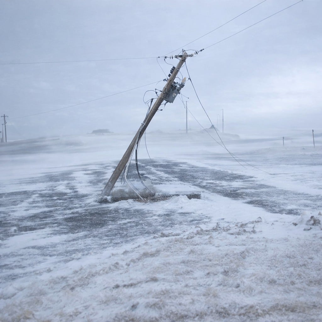
In Edmonton, Epcor reported nearly 2,000 customers in the Crestwood, Grovenor, Parkview, and River Valley Capitol Hill neighbourhoods lost power. The city had three active outage zones as of Sunday afternoon.

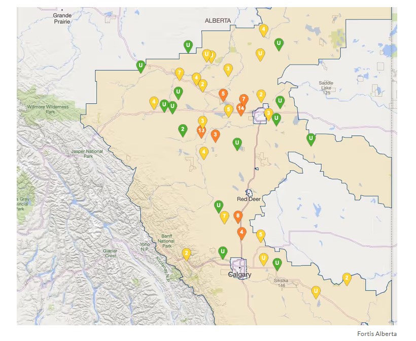
Province-wide, Fortis Alberta's outage map lit up around midday. Drayton Valley, Stony Plain, Spruce Grove, Carstairs, and Beiseker were all showing outages simultaneously. By the afternoon, Fortis Alberta estimated roughly 8,000 Alberta residents had lost power.
Fortis Alberta spokesperson Tanya Croft described it plainly: "Strong winds and heavy snow are causing downed power lines, trees contacting power lines and infrastructure damage."
ATCO reported additional outages in northwestern Alberta, and over in B.C., BC Hydro said about 1,900 customers in the Southern Interior lost power roughly half of them in Vernon, mostly from trees taking down lines.
Snow on Top of It All
The wind alone would have been enough. But southern Alberta also got snow.
Calgary, the foothills corridor, Banff, Strathmore, Waterton Lakes, and Vulcan were all looking at up to 20 centimetres before things tapered off Sunday night. The Weather Network had flagged this pattern as early as Thursday a Pacific clipper system strengthening and sweeping a cold front south into Alberta, with upslope snow developing along the southern foothills by Sunday evening.
Fort McMurray, tracking the original clipper more directly, was also in line for up to 20 cm.
Roads Were a Mess
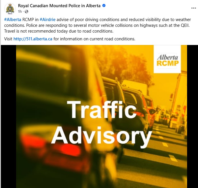
In Airdrie, RCMP issued a statement just before 12:30 p.m. asking residents to stay off the roads. Blowing snow was killing visibility on area highways, and officers were already responding to multiple collisions on the QE II.
ECCC specifically called out high-sided vehicles RVs, commercial trucks, vehicles towing trailers as being at real risk of being pushed around. This wasn't a boilerplate warning. Sustained 100+ km/h gusts have enough force to physically push a loaded trailer sideways.
What Was Behind This Meteorologically
This wasn't a random bad day. The Weather Network described it as a return of a Pacific weather pattern warm, downsloping winds building pressure along the foothills Saturday (temperatures near Highway 1 flirted with 20°C before the front moved in), followed by a hard cold front swing from the north late Saturday into Sunday.
The clipper system then strengthened and tracked east toward Manitoba, but its associated cold front dragged north winds of up to 80 km/h into central Alberta. Southern Alberta stayed warmer longer due to the downsloping westerly winds which is why Calgary saw snow while parts of Lethbridge and the south were still relatively mild earlier in the day.
The Safety Reminders That Actually Matter
A few things worth keeping in your back pocket for the next event like this:
Stay 10 metres away from downed power lines electricity can arc through wet ground further than most people realize
Check your utility's outage map before calling in Fortis Alberta, ATCO, Epcor, and Enmax all have live maps
High-profile vehicles (moving trucks, trailers, anything boxy) should stay off the QE II and Highway 2 corridor during events like this
If your power's out, assume lines near your property are live until told otherwise
Where Things Stood Sunday Evening
By late afternoon, winds were expected to ease. BC Hydro was targeting Sunday evening for most restorations. Fortis Alberta crews were actively working across the province.
The snow in southern Alberta was still coming down as of the afternoon, with the bulk expected to taper overnight into Monday.
Spring, despite what the calendar says, is still very much a negotiation in Alberta.
Sources:
Environment and Climate Change Canada — Wind Warning Statements, March 8, 2026
Fortis Alberta — Official Statement via spokesperson Tanya Croft, March 8, 2026
Epcor — Edmonton Outage Map, March 8, 2026
ATCO — Alberta Outage Map, March 8, 2026
BC Hydro — Southern Interior Outage Update, March 8, 2026
RCMP Airdrie — Travel Advisory Statement, March 8, 2026
The Weather Network Forecast Centre — Weekend Travel Alert, March 6, 2026


Comments
Conversation