
A severe thunderstorm swept the corridor north and west of Edmonton late Thursday night, and the thing everyone reported first was the lightning.
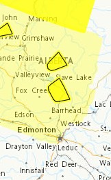
Environment Canada issued a severe thunderstorm warning at 10:55 p.m. Radar indicated quarter-sized hail. The alerts have since ended, and no warnings are in effect Friday morning.
Which communities were in the path
The alerts covered a band running from the foothills northeast toward Edmonton, hitting the northern and western parts of the region hardest.
Sturgeon County near Morinville, Volmer and Big Lake, and near Rivière Qui Barre and Villeneuve.
Westlock County near Westlock and Clyde, and near Larkspur, Fawcett and Jarvie.
Thorhild County near Newbrook and Long Lake Provincial Park.
Woodlands County near Whitecourt and Blue Ridge, near Fort Assiniboine, Timeu and Topland, near Goose Lake, and near Carson-Pegasus Provincial Park.
Yellowhead County near Big Berland and the Wildhay River.
Big Lake sits on St. Albert's southern edge, which is where the heaviest reports came from.
Earlier Thursday afternoon, Environment Canada meteorologists tracked a line of severe thunderstorms running from Devon to Spruce Grove, moving northeast at 30 km/h.
What people reported
"Wow what a light show," a St. Albert resident posted just after 11 p.m. "I couldn't believe how hard the rain came down and the hail."
"It's like a freaking strobe light out there," another replied.
A resident near Clyde, roughly 70 kilometres north of Edmonton and inside the Westlock County alert area, described the same thing. "It's getting pretty bright up here. Like a strobe light." No hail there, but rain drops described as very big and very loud.
What the storm brought
The main threats were hail and heavy rain.
Quarter-sized hail is roughly 25 millimetres. Enough to dent vehicle panels, crack windshields, strip siding and shred gardens. It sits below the size that typically injures people, but it falls fast enough that being outside in it isn't something to do voluntarily.
Environment Canada warned the heavy rain could cause flash flooding and significant reductions to visibility, with difficult driving conditions and likely travel delays.
Check your vehicle this morning
Hail damage is the most common and costly outcome of a night like this in Alberta, and it's easiest to see in daylight.
Look at the hood, roof and trunk lid, where dents show up first. Check the windshield for chips that weren't there Thursday. Photograph anything you find before you drive anywhere, and note the date.
Hail damage to a vehicle is covered under comprehensive insurance, which is optional in Alberta. Liability and collision alone will not cover it.
For a house, check the roof, siding, screens and any skylights. Roof damage from hail often isn't visible from the ground and can surface the following spring as water in a ceiling, so if your area took a direct hit, an inspection while the damage is fresh is worth the call.
A summer of storms across the region
Thursday was the latest in a stretch that hasn't let up since early July.
July 8 brought two confirmed tornadoes to east-central Alberta, one of them tearing through the Dillberry Lake Provincial Park campground, flipping trailers and sending three people to hospital.
July 10 brought an intense line of storms with the heaviest core over St. Albert, tracking through Spruce Grove, Stony Plain and Morinville, with hail up to golf-ball size and gusts near 100 km/h.
July 25 brought a severe thunderstorm warning and an emergency alert for very large hail near Entwistle, along with a tornado warning that was later cancelled. That storm cut short a Post Malone show at Commonwealth Stadium and flooded streets across the city.
July 31 brought a tornado watch covering Spruce Grove, Stony Plain and Morinville, with baseball-sized hail possible.
One Edmonton-area storm watcher counted Thursday as the eighth severe storm of the year for the corridor west of the city through St. Albert, Morinville and Gibbons. That's an enthusiast's tally rather than an official count, but it matches what the region has been through.
Alberta Tornado Tears Through Dillberry Lake Campground Near Lloydminster, Campers Sent to Hospital
The rain has been relentless
Edmonton recorded its wettest June on record this year at 262 millimetres, breaking a mark that had stood since 1914 and more than tripling the historical average. By the end of July the region had taken more than 655 millimetres of precipitation since the start of 2026.
Those storms flooded basements and roads, backed up sewers and triggered Alberta Emergency Alerts for water conservation across Edmonton, St. Albert, Stony Plain and Beaumont.
Ground that's been saturated repeatedly has less capacity to absorb new water, which is why a fast, heavy downpour turns into flash flooding on roads that drained fine a decade ago.
What comes next: a clear weekend
The turn is sharp.
Friday is sunny with a high of 24, dropping to 11 overnight. Saturday is mainly sunny and 23. Sunday brings a mix of sun and cloud at 21 with a 40 per cent chance of a shower.
The next real rain in the forecast is Wednesday, September 2, with 10 to 15 millimetres possible.
And a lunar eclipse
Thursday night's clearing brought something worth looking up for.
A nearly total lunar eclipse is visible, and forecasters say the northern lights may appear alongside it. After four severe storms in seven weeks, the viewing conditions are about as good as they've been all summer.
How to stay informed
Alberta Emergency Alert pushes the most serious warnings straight to your phone, and weather.gc.ca has live watches and warnings for your exact location, which is the fastest way to know if a cell is about to hit your neighbourhood.
If you see severe weather, Environment Canada takes reports at ABstorm@ec.gc.ca, by phone at 1-800-239-0484, or on social media with #ABStorm.
Road conditions are at 511.alberta.ca or by dialling 511 in Alberta.
Did you take damage Thursday night? Send us your photos and tell us where you were. We'll add them to this story.
Sources
Environment and Climate Change Canada, severe thunderstorm alerts for Sturgeon, Westlock, Thorhild, Woodlands and Yellowhead counties, August 27, 2026 (weather.gc.ca) Environment and Climate Change Canada, Edmonton forecast Alberta Emergency Alert (emergencyalert.alberta.ca) Alberta 511
Resident reports from St. Albert and the Clyde area, posted publicly Thursday evening. Storm count from a local weather observer.









Comments
Conversation