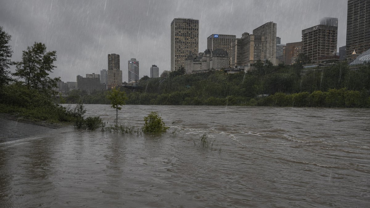
Edmonton has not dried out from last weekend. Another major storm is moving in and this one could push the city into record territory.
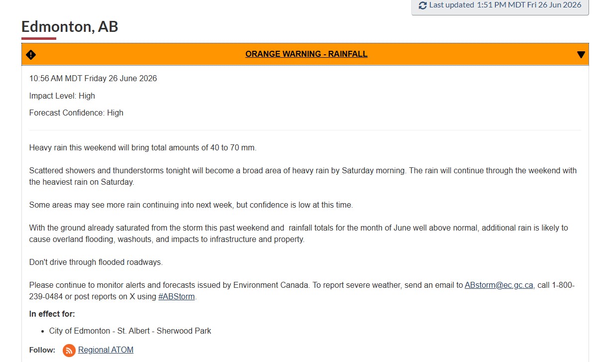
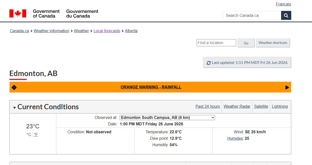
Environment Canada issued orange-level rainfall warnings Friday morning covering Edmonton, Sherwood Park, and St. Albert, along with a wide stretch of central Alberta running from Fox Creek and Edson in the west to Vermilion and Wainwright in the east. Between 40 and 70mm of rain is forecast through the weekend. The heaviest rain hits Saturday.
Orange is the second-highest alert level. It means the storm is severe and expected to cause major widespread damage or disruptions specifically overland flooding, road washouts, and impacts to infrastructure and property.
Scattered showers and thunderstorms move in Friday evening. By Saturday morning those build into what Environment Canada is calling a broad area of heavy rain.
Edmonton is 13mm from breaking a 112-year record
This June has been extraordinary. As of Monday, Edmonton had recorded 203mm of rain for the month already matching the second-wettest June ever recorded, set in 1965. The all-time June record belongs to 1914 when 216.5mm fell on the capital region. With another 40 to 70mm forecast this weekend, Edmonton is on track to break that 112-year-old record.
"I would say reaching the second most rain ever in a month is a strong bet, and I think with the amount of rain we could get this weekend, we will get into striking distance of the July 1901 record," said Matt Loney, meteorologist with Environment Canada. Edmonton's all-time single-month rainfall record was set in July 1901 when 282mm fell.
"If we get some embedded thunderstorms, it could increase the chances that we break the all-time record," Loney added.
Areas west of Edmonton could see even more Loney said the Edson and Foothills areas near Calgary could receive up to 100mm this weekend.
Why this weekend is more dangerous than a normal rain event
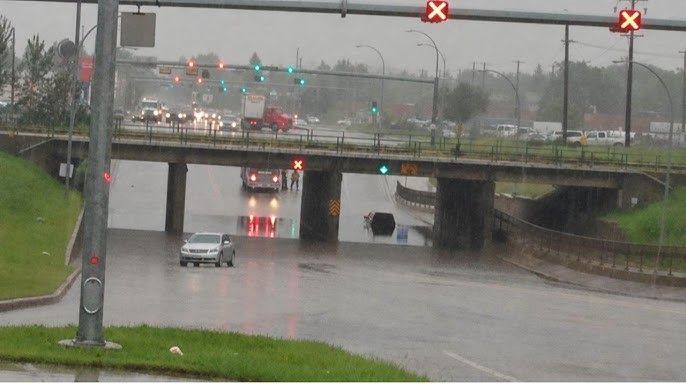
The ground across central Alberta is still waterlogged from the June 20-21 storm that dropped up to 140mm in parts of the region and pushed municipal wastewater systems to capacity across Edmonton and surrounding communities. EPCOR received more than 700 flooding calls in a single day during that event. Flooded basements, sewer backups, and washed-out roads were reported from dozens of communities.
When saturated ground gets hit with another major rainfall, water has nowhere to go. Overland flooding happens faster and at lower rainfall totals than it would on dry ground. Rural regions around Edmonton are still dealing with active flooding Lac Ste. Anne County, Beaver County, and Tofield all had active Alberta Emergency Alerts as of Friday. Multiple river basins including the North Saskatchewan, Red Deer, Battle, Beaver, Athabasca, Peace, and Hay rivers are all running above normal.
The High Level Bridge east sidewalk is now closed
The rain has already caused visible infrastructure damage in the city. On Thursday evening the City of Edmonton closed the east sidewalk on the High Level Bridge after the slope next to the wooden guardrail experienced failure, making it unsafe.
"We've seen some areas of erosion that needs to be clearly addressed for safety reasons," said Mayor Andrew Knack. "It's not entirely unexpected based off the sheer volume of rain that we've seen. The fact that even with the last couple days of sunshine, the grounds are still pretty saturated."
The east sidewalk remains closed until further notice. Pedestrians can cross using the west sidewalk.
This is not ending after the weekend
Once the weekend storm clears, there is no clear break coming. Loney said a nice day on Monday is possible followed by another upper trough descending and more instability with thunderstorms and showers.
"The early portion of this summer, these upper troughs have played a major role in the weather picture," he said. The pattern driving this wet summer is a series of upper low pressure troughs dropping in from the Pacific northwest and drawing moisture into central Alberta. Breaking that pattern is not guaranteed.
"It all depends if we can snap out of this pattern," Loney said. July does not look drier.
What to do this weekend
Do not drive through flooded roads. Water depth is impossible to judge visually and moving water can push a vehicle off course. Turn around.
Check your sump pump now before Saturday morning. Make sure it is running and discharging properly.
Delay laundry, dishwasher use, and other non-essential water use during and after heavy rain to reduce pressure on municipal wastewater systems.
Clear debris from drain grates and catchbasins near your property.
For current warnings visit weather.gc.ca. To report severe weather contact Environment Canada at ABstorm@ec.gc.ca or call 1-800-239-0484. For basement flooding in Edmonton contact EPCOR at 780-412-4500. For road conditions call 511.
Sources:
Environment Canada, orange-level rainfall warning for Edmonton and central Alberta, June 26, 2026 (weather.gc.ca)
Environment Canada, meteorologist Matt Loney statements, June 26, 2026
CBC News, Edmonton central Alberta expected to get drenched with up to 70mm of rain, June 26, 2026 (cbc.ca)
Edmonton Journal, Orange alert: Brace for impact as Edmonton set to break 112-year June rainfall record, June 26, 2026 — Matt Loney quotes and High Level Bridge details