Alberta is heading into another dangerous weather day and the risk is real across most of the province.
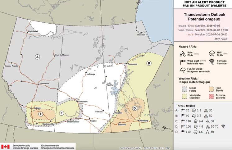
Environment Canada's Storm Prediction Centre issued a thunderstorm outlook for July 5 flagging southern Alberta under the highest risk category. A severe thunderstorm warning was already issued Saturday at 4:52 p.m. MDT for an extremely dangerous storm north of Bentley moving east at 50 km/h — covering Lacombe, Blackfalds, Bentley, Clive, Alix, Mirror, Ponoka, and Maskwacis. Meteorologists described it as capable of producing damaging wind gusts, heavy rain, and hail larger than a baseball.
This is the second straight day of severe weather across Alberta. The atmosphere has not stabilized between events.
Check weather.gc.ca for current warnings in your area before heading out.
Where the risk is highest and what is coming
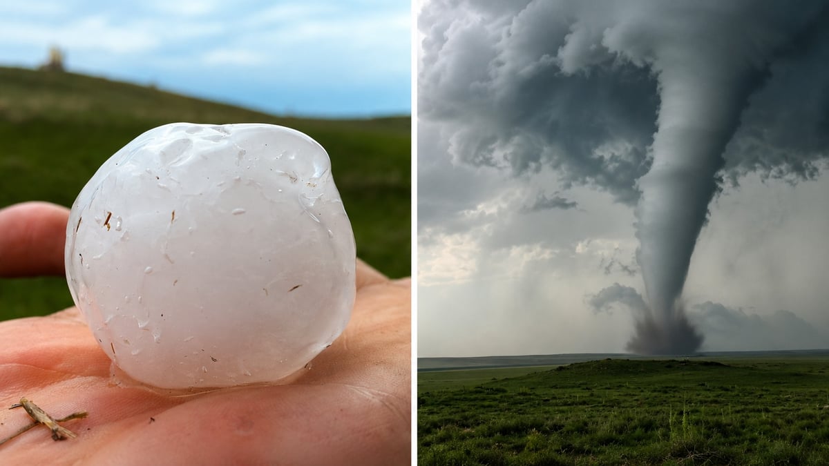
Southern Alberta is in the most dangerous zone today. Communities along and south of Highway 2 Brooks, Vulcan, High River, Nanton, and the corridor running south toward Lethbridge face hail up to six centimetres, wind gusts up to 110 km/h, a tornado risk, and up to 50 mm of rain. Six centimetres is large enough to shatter windshields, dent vehicles, and cause serious injury on contact. At terminal velocity, hail that size falls at roughly 160 km/h.
Calgary, Airdrie, Cochrane, Chestermere, Medicine Hat, Lethbridge, and Edmonton all sit in the moderate risk zone. Four-centimetre hail is possible the size of a large marble or small golf ball. Wind gusts up to 90 km/h. Up to 30 mm of rain. That is not a safe day to be standing in an open field.
Grande Prairie, Fort McMurray, Hinton, Edson, High Level, Peace River, Banff, and Jasper face a lower but still meaningful risk one to two centimetre hail, gusts up to 70 km/h, up to 20 mm of rain.
What is driving this
A strengthening low-pressure system and upper-level energy are combining with warm, humid air and strong wind shear the exact combination that produces supercell thunderstorms. Supercells are the storm type most associated with large hail, destructive winds, and tornadoes. The Weather Network confirmed a tornado cannot be ruled out for some areas as supercells will be possible across central and southern Alberta through the afternoon and into the evening.
The setup today is not a typical afternoon pop-up storm. It is a system with organized energy behind it arriving into an unstable atmosphere that has been primed by two weeks of above-normal heat and moisture across the province.
Central Alberta already got hit yesterday
Parts of Lacombe and Ponoka counties were struck by severe thunderstorms Saturday afternoon. The storm that triggered the 4:52 p.m. warning was tracked moving east from north of Bentley through Lacombe, Blackfalds, Clive, Alix, Mirror, Ponoka, and Maskwacis. Large hail fell across those communities. The warning noted the storm was also capable of spawning tornadoes.
That same system continued east into the evening, with severe weather remaining possible across portions of Alberta as a volatile combination of heat, humidity, and favourable upper-level conditions continued to support strong storm development.
The Stampede factor
The Calgary Stampede opened July 3. Hundreds of thousands of people are at or travelling to outdoor events, pancake breakfasts, and Stampede Park this weekend. Severe thunderstorms in Calgary develop fast the window between a watch and a warning can be under 30 minutes. Anyone at outdoor Stampede events this afternoon should know where the nearest indoor shelter is before the storm arrives, not after.
The Stampede grounds have covered areas but the midway, infield, and surrounding streets do not. If a warning is issued for Calgary, get inside a permanent structure not a tent or temporary canopy.
What to do when a warning is issued
Get inside a sturdy building immediately. Stay away from windows. Do not shelter under trees they attract lightning and can fail in high winds. If you are driving when hail begins, pull off the road, angle the vehicle so the hail hits the front of the car rather than the windshield, turn on hazard lights, and stay low below window level. Driving through large hail is one of the most common causes of serious vehicle damage and accidents during Alberta thunderstorms.
If a tornado warning is issued, go to the lowest floor of a building, away from windows, and protect your head. Do not try to outrun a tornado in a vehicle.
Make sure emergency alerts are turned on for your phone. Alberta's emergency alert system will push a notification directly to your device if a tornado warning is issued in your area.
Check weather.gc.ca for current watches and warnings updated in real time.
Sources:
Environment Canada, Storm Prediction Centre thunderstorm outlook July 5, 2026 (weather.gc.ca)
Environment Canada, severe thunderstorm warning Lacombe and Ponoka counties, 4:52 p.m. MDT July 4, 2026 (weather.gc.ca)
Government of Alberta, Alberta Emergency Alert, severe thunderstorm warning July 4, 2026 (alberta.ca/alberta-emergency-alert.aspx)
Government of Alberta, Thunderstorms, lightning, heavy rain and hail safety page (alberta.ca/thunderstorms-lightning-heavy-rain-and-hail)
The Weather Network, tornado risk and severe storm setup July 5, 2026 (theweathernetwork.com)