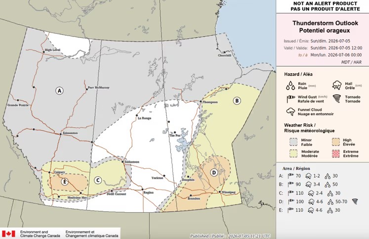
Southern Alberta is under an orange severe thunderstorm alert as of Sunday morning. Dangerous thunderstorms are expected to develop this afternoon and continue into the evening across a wide swath of the province running along the Alberta-Saskatchewan border and northwest into the Calgary region.
Environment and Climate Change Canada classified both its confidence and impact level as high. The orange designation is used when forecasters expect higher-impact severe weather with major, widespread consequences a step above the yellow watches Albertans see most commonly during summer storm season.
Who is under the alert
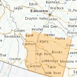
The orange alert covers Lethbridge, Medicine Hat, Brooks, Taber, Claresholm, and communities along and near the Alberta-Saskatchewan border. Calgary and the surrounding region are included.
The rest of Alberta is not off the hook. Grande Prairie, Fort McMurray, Edmonton, Lloydminster, and the Rockies corridor all face a lower-tier risk, with storms capable of wind gusts up to 70 km/h, one-centimetre hail, and up to 30 mm of rain.
What is coming this afternoon
Wind gusts up to 100 km/h are possible in the Lethbridge and Medicine Hat areas, strong enough to damage trees, buildings, and overturn vehicles. In Calgary, gusts up to 60 km/h. Damaging hail across the region. Heavy rain with flash flooding potential. A tornado cannot be ruled out.
"Heavy rain can cause flash flooding and significant reductions to visibility. Strong wind gusts can damage trees, buildings and overturn vehicles. Large hail can cause significant damage and injury," Environment Canada's alert states.
Most intense activity is expected around 4 p.m.
What makes southern Alberta particularly vulnerable today
Lethbridge and Medicine Hat sit in an open prairie corridor with no natural windbreaks between them and the Saskatchewan border. When organized thunderstorms develop in this zone and track northeast the dominant movement today they can intensify quickly with few obstacles to break them up.
Southern Alberta also sits closer to the dry line the boundary between hot, dry air pushing up from Montana and Idaho and warm, humid air moving in from the east. That boundary is one of the most reliable triggers for supercell development in Western Canada. When the dry line fires in July the storms that form are often the most intense of the season. What starts as a severe thunderstorm watch can escalate to a tornado warning in under 30 minutes.

What already happened in southern Alberta yesterday
Saturday was not a quiet day. A tornado warning was issued for Special Area No. 2 near Spondin and Scapa in east-central Alberta at 6:30 p.m. on July 4. It was updated nine times over more than an hour before being lifted. Large hail fell across central Alberta communities including Lacombe, Blackfalds, Ponoka, and Maskwacis.
The same combination of heat, moisture, and upper-level energy that produced Saturday's severe storms is in place again today. Forecasters are not treating this as a lesser setup.
How southern Alberta compares to the rest of Canada today
This is not an isolated Alberta event. The same upper-level pattern driving today's severe weather is part of a broader North American setup. A deep trough over the Pacific Northwest is funnelling instability into the Canadian prairies, while heat from the south is pushing moisture northward into Alberta and Saskatchewan.
Environment Canada's Storm Prediction Centre has flagged Saskatchewan under similar risk today, with the threat corridor running continuously from southern Alberta through Regina and into Manitoba. That is a thousand-kilometre stretch of volatile atmosphere moving together.
For Lethbridge and Medicine Hat residents the practical implication is that the storms forming today are likely part of a larger organized system that will move through the region rather than popping up and dissipating quickly. Organized systems last longer, cover more ground, and produce more sustained severe weather than isolated pop-up storms.
What the south looks like compared to the north
The risk is not evenly distributed across Alberta. The southern half from the US border north to Calgary and east to Saskatchewan is carrying the heaviest load today. Lethbridge and Medicine Hat are under the orange alert. Edmonton is not. Grande Prairie is not.
Outdoor exposure will carry higher risk this afternoon, especially in open areas near Lethbridge, Medicine Hat, Taber, Claresholm, and Brooks.
What to do
If a warning is issued for your area, get inside a sturdy building and stay away from windows. During large hail, pull off the road, turn hazard lights on, and stay below window level. Do not drive through flooded roads.
If a tornado warning is issued, go to the lowest floor of a building, away from windows. Do not try to outrun a tornado in a vehicle.
Make sure emergency alerts are enabled on your phone. Environment Canada updates weather.gc.ca in real time.
Sources:
Environment and Climate Change Canada, orange alert for southern Alberta severe thunderstorm activity, July 5, 2026 (weather.gc.ca)
Environment and Climate Change Canada, Storm Prediction Centre thunderstorm outlook July 5, 2026 (weather.gc.ca)
Government of Alberta, Alberta Emergency Alert, tornado warning Special Area No. 2, July 4, 2026 (alberta.ca/alberta-emergency-alert.aspx)