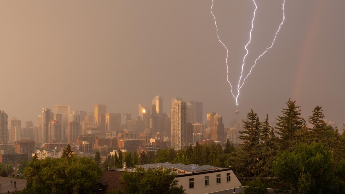
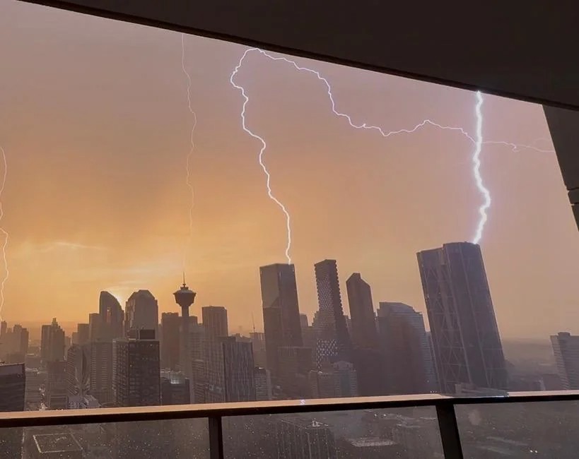
Videos and photographs shared during Calgary's thunderstorm on Saturday, August 15, show bright channels stretching from the skyline toward the clouds, several appearing almost at once.
It's not a camera trick. The pattern is consistent with a phenomenon called upward lightning, in which an electrical leader develops from a tall structure and travels toward the cloud rather than the other way around.
The storm
Environment Canada issued a severe thunderstorm watch for Calgary at 8:23 p.m. Saturday, warning of strong wind gusts, large hail and heavy rain. A severe thunderstorm warning followed at 8:52 p.m. and remained in effect until 9:32 p.m.
It was during that window that images of the unusual lightning began circulating.
What upward lightning is
Most people picture lightning as something that leaves a cloud and hits the ground. Upward lightning reverses that sequence.
A strong electric field around the top of a tall building, communications tower or wind turbine can initiate an electrical leader that propagates upward toward the cloud.
Height matters. Structures around 100 metres and taller are particularly susceptible, although the conditions depend on more than height alone.
Calgary has a cluster of structures in that range concentrated in a compact downtown, which is the kind of environment where this can occur.
What the shape can tell you
One clue is the branching pattern.
In an ordinary downward flash, the channel emerges from the cloud and splits as it descends, so the forks point toward the ground.
In an upward flash, branching can develop above the structure as the leader propagates toward the cloud. The channel begins narrow at its base and opens as it rises.
In Saturday's images, several channels appear to converge toward individual points around rooftop height before branching higher in the sky. That's consistent with upward lightning, although determining exactly how a flash developed requires more than a single photograph.
Why several buildings can flash almost simultaneously
Researchers have documented this happening.
A study in Rapid City, South Dakota recorded upward lightning developing from four towers spread across 2.9 kilometres following a nearby positive cloud-to-ground flash. The upward leaders began roughly two milliseconds after the triggering return stroke.
A separate study documented upward flashes initiating from two towers 3,420 metres apart, within four milliseconds of each other, both lasting more than 250 milliseconds. In that case both were self-initiated from the towers as upward positive leaders.
What looks like several buildings independently firing lightning into the sky can be different structures responding almost simultaneously to the same electrical disturbance.
That's one plausible explanation for what happened over Calgary. Without instrument data tied to Saturday's videos, it isn't possible to say what triggered each flash.
What can trigger it
Upward lightning can develop on its own under the right electrical conditions, which researchers call self-initiated. It can also be triggered by another nearby lightning discharge.
Studies of towers in Rapid City found preceding lightning activity in nearly every upward flash recorded during summer months, with positive cloud-to-ground strikes among the common triggers.
Research at the Gaisberg Tower in Austria has gone further, using machine learning against meteorological reanalysis data to identify which conditions favour self-initiation. The strongest single factor turned out to be the height of the minus-10-degree isotherm above the structure. The closer that layer sits to the tower, the higher the probability the tower initiates a flash on its own.
Both mechanisms produce the same visual result from the ground.
Why it may not appear on lightning maps
Not every upward flash is reliably detected by conventional lightning location systems.
Some contain a relatively long continuous current without the strong electrical pulse those networks are best at locating. Measurements from specially instrumented towers have found that a substantial portion of upward lightning goes undetected by conventional networks entirely.
Globally, only a small number of towers are equipped to measure this directly. Much of what is known has come instead from high-speed camera work. One long-running Rapid City project filmed 776 naturally occurring flashes, of which 41 were upward flashes from towers.
A lightning map showing nothing at a particular building doesn't establish that nothing happened there.
That makes original phone footage more useful than it might seem, particularly when the exact time and shooting location are known.
Why this matters for tall structures
Wind turbines keep getting taller, and the taller a structure is, the more favourable it becomes for upward lightning.
These flashes can transfer substantial charge over a longer period than a typical downward strike, which makes them a recognized source of damage rather than a curiosity. Research published in the Journal of Geophysical Research: Atmospheres has examined upward lightning at wind turbines specifically as a risk assessment problem.
That's relevant in a province where tall urban buildings and large wind turbines both sit beneath the same summer thunderstorms. Southern Alberta has been adding turbines steadily, and Calgary's downtown already provides the other half of the picture.
If you filmed it
Keep the original file rather than only the compressed social media copy.
The exact time, the location you shot from, and the uninterrupted sequence before and after the flash all help establish what happened and which structures were involved. Compression strips metadata and detail, and a screen recording of a reposted clip loses both.
Environment Canada takes public severe weather reports at ABstorm@ec.gc.ca, by phone at 1-800-239-0484, or on social media with #ABStorm.
Send us your video too, with the time and where you were standing. We'll add the best of it to this story.
Sources
Environment and Climate Change Canada, severe thunderstorm watch and warning for the City of Calgary,
August 15, 2026 Warner et al., Observations of Simultaneous Upward Lightning Leaders From Multiple Tall Structures Warner et al., upward lightning observations from towers in Rapid City, South Dakota Concurrent Upward Lightning Flashes from Two Towers, Atmospheric and Oceanic Science Letters
Upward Lightning at the Gaisberg Tower, Journal of Geophysical Research: Atmospheres
Upward Lightning at Wind Turbines: Risk Assessment From Larger-Scale Meteorology, Journal of Geophysical Research: Atmospheres Royal Meteorological Society








Comments
Conversation