Damaging winds are hitting Calgary and southern Alberta on Sunday, Nov. 8. Once they pass, one of the warmest November weeks in recent memory follows.
Environment Canada’s warning calls for gusts of 90 to 100 km/h, strongest in the afternoon. Closer to the U.S. border, gusts could exceed 110 km/h. Sustained winds will run 40 to 60 km/h. The wind starts easing Sunday evening.
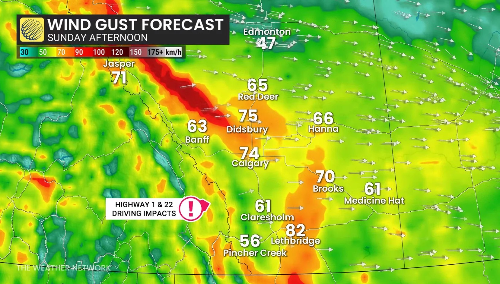
Where the wind warnings are
The Weather Network’s Sunday report lists Calgary, Airdrie, Brooks, Cardston, Cypress Hills, Drumheller, Hinton, Lethbridge, Medicine Hat, Nordegg, Okotoks and Rocky Mountain House among the areas under warning.
Environment Canada’s Calgary bulletin also covers surrounding communities, including Cochrane, Bragg Creek, Chestermere and De Winton.
Warning boundaries change through the day. Check the alert for your location before you drive anywhere.
When Calgary’s wind eases
The strongest gusts are forecast for Sunday afternoon, with conditions improving through the evening and overnight.
Environment Canada’s hourly forecast for Calgary has southwest gusts near 90 km/h through late afternoon, dropping to about 80 km/h in the early evening and 50 km/h later in the evening. Those are forecast values. Conditions vary by neighbourhood and exposure.
Why it’s so windy
A low-pressure system moving out of British Columbia across northern Alberta is driving strong downslope winds, according to The Weather Network. Strong winds high in the atmosphere are mixing down to the surface on the east side of the Rockies, which is why the south and foothills are under warning and Edmonton is not.
It is the second wind event in three days. Calgary had a warning Friday night, and Edmonton had one overnight into Saturday. Sunday’s is a new system.
What to secure while the warning is in effect
Environment Canada advises securing loose objects and preparing for possible disruptions to transportation, services and utilities.
Bring in or tie down patio furniture, trampolines, garbage bins and any decorations still outside.
Park away from large trees.
If you are towing or driving anything high-sided, give yourself extra room, especially on Highway 2 south of Calgary, Highway 3 through the Crowsnest and Highway 1 west of the city.
Check 511 Alberta before a highway trip.
If you lose power in Calgary, ENMAX’s trouble line is 403-514-6100. Outside the city, FortisAlberta is 310-WIRE (310-9473). Stay well back from any downed line and call 911.
The warm week ahead
The same Pacific air behind Sunday’s wind is about to do something more pleasant.
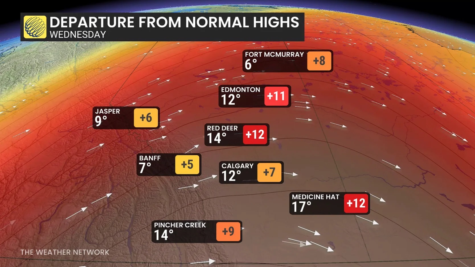
The Weather Network expects mild Pacific air moving over the Rockies to keep the Prairies unusually warm through the coming week. By Wednesday, temperatures in much of Alberta could be nearly 15 degrees above seasonal averages. Some favourable spots in southern Alberta may reach 20°C.
That does not mean every city hits 20, and nights will still be cool. But the mild stretch covers the whole province, Edmonton included.
Forecast highs: Calgary, Lethbridge and Edmonton
Daytime highs in °C, from forecast data checked Sunday afternoon:
| Mon | Tue | Wed | Thu | Fri | Sat | |
|---|---|---|---|---|---|---|
| Calgary | 10 | 11 | 13 | 15 | 14 | 12 |
| Lethbridge | 12 | 13 | 16 | 18 | 15 | 12 |
| Edmonton | 10 | 7 | 9 | 9 | 9 | 8 |
Calgary’s overnight lows are forecast to stay above freezing most of the week. Edmonton’s drop below zero at night.
These will shift. Check the Environment Canada forecast for your city before making outdoor plans.
Heading to Calgary for the Grey Cup?
The game is Sunday, Nov. 15 at McMahon Stadium. A week out, no forecast is worth quoting yet. Our Grey Cup guide has the schedule, free festival events and how to get to the stadium, and we will update it with the weather closer to game day.
For Sunday, the wind is the story. The warm-up comes after.
Sources:






Comments